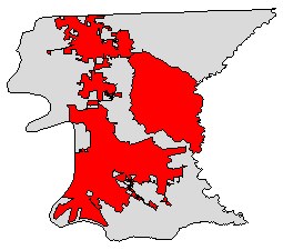
CITY_LIMIT_25b2b82e-5be2-445d-8935-093be85c3e1a

Identification_Information
Data_Quality_Information
Spatial_Data_Organization_Information
Spatial_Reference_Information
Entity_and_Attribute_Information
Distribution_Information
Metadata_Reference_Information
Identification Information
Section Index
Citation:
Citation Information:
Title: CITY_LIMIT_25b2b82e-5be2-445d-8935-093be85c3e1a
Description:
Abstract:
This dataset displays the boundaries of the incorporated cities within East Baton Rouge Parish. The city limits are added or updated when annexations have been affected by the appropriate local legislative bodies. The Department of Information Services is responsible for the maintenance and update of this layer.
Purpose: To display city limits as a base map layer for East Baton Rouge Parish.
Supplemental Information: The extents are the Parish of East Baton Rouge, LA
Time Period of Content:
Currentness Reference: Best Available
Status:
Maintenance and Update Frequency: As needed
Spatial Domain:
Bounding Coordinates:
West Bounding Coordinate: -91.247471
East Bounding Coordinate: -90.967666
North Bounding Coordinate: 30.709003
South Bounding Coordinate: 30.338380
Keywords:
Theme:
Theme Keyword Thesaurus: None
Theme Keyword: Annexation
Theme Keyword: City Limits
Theme Keyword: Incorporated
Place:
Place Keyword Thesaurus: None
Place Keyword: East Baton Rouge Parish
Place Keyword: City of Baton Rouge
Place Keyword: City of Baker
Place Keyword: City of Central
Place Keyword: City of Zachary
Access Constraints: copyright
Point of Contact:
Contact Information:
Contact Person Primary:
Contact Person: Justin Priola, GISP
Contact Organization: City of Baton Rouge/Parish of East Baton Rouge, Department of Information Services
Contact Position: GIS Manager
Contact Address:
Address: 222 Saint Louis St., Room B-284
City: Baton Rouge
State or Province: LA
Postal Code: 70802
Country: United States of America
Contact Voice Telephone: +1-225-389-3070
Contact Facsimile Telephone: +1-225-389-7745
Contact Electronic Mail Address: jpriola@brla.gov
Browse Graphic:
Browse Graphic File Description: thumbnail
Browse Graphic:
Browse Graphic File Description: large_thumbnail
Data Quality Information
Section Index
Lineage:
Source Information:
Source Citation:
Source Scale Denominator: 4800
Type of Source Media: Ordinance
Source Time Period of Content:
Source Currentness Reference: ground condition
Cloud Cover: 0
Spatial Data Organization Information
Section Index
Indirect Spatial Reference: NAD_1983_StatePlane_Louisiana_South_FIPS_1702_SurveyFeet
Direct Spatial Reference Method: Vector
Point and Vector Object Information:
SDTS Terms Description:
Point and Vector Object Count: 4
Spatial Reference Information
Section Index
Horizontal Coordinate System Definition:
Local:
Local Description: NAD_1983_StatePlane_Louisiana_South_FIPS_1702_SurveyFeet
Geodetic Model:
Semi-major Axis: 0.000000
Denominator of Flattening Ratio: 0.000000
Entity and Attribute Information
Section Index
Detailed Description:
Entity Type:
Entity Type Label: Captured
Attribute:
Attribute Label: AREA_SQ_MILES
Attribute:
Attribute Label: CITY_LIMITS_NAME
Attribute:
Attribute Label: CREATED_DATE
Attribute:
Attribute:
Attribute Label: MODIFIED_DATE
Distribution Information
Section Index
Distributor:
Contact Information:
Contact Person Primary:
Contact Person: Michael Stein
Contact Organization: City of Baton Rouge/Parish of East Baton Rouge, Department of Information Services
Contact Position: GIS Coordinator
Contact Address:
Address: 222 Saint Louis St., Room B-284
City: Baton Rouge
State or Province: LA
Postal Code: 70802
Country: United States of America
Contact Voice Telephone: +1-225-389-3070
Contact Facsimile Telephone: +1-225-389-7745
Contact Electronic Mail Address: mstein@brla.gov
Distribution Liability:
The City of Baton Rouge and Parish of East Baton Rouge provides this information in good faith with no warranty and does not accept any liability arising from incorrect, incomplete or misleading information or improper use. The data presented by the City-Parish are intended to serve only for reference or analysis when researching property, governmental boundaries, infrastructure, transportation, environmental and other data categories. The City-Parish takes no legal responsibility for the accuracy of its data, and users are advised not to rely solely on the information provided by the East Baton Rouge Parish Geographic Information System (EBRGIS).
Technical Prerequisites: The extents are the Parish of East Baton Rouge, LA
Metadata Reference Information
Section Index
Metadata Contact:
Contact Information:
Contact Person Primary:
Contact Person: Ron Frebis
Contact Organization: City of Baton Rouge/Parish of East Baton Rouge, Department of Information Services
Contact Position: Project Manager
Contact Address:
Address: 222 Saint Louis St., Room B-284
City: Baton Rouge
State or Province: LA
Postal Code: 70802
Country: United States of America
Contact Voice Telephone: +1-225-389-3070
Contact Facsimile Telephone: +1-225-389-7745
Contact Electronic Mail Address: rfrebis@brla.gov
Metadata Standard Name: [[FGDC CSDGM derived from ]]ISO 19115:2003/19139
Metadata Standard Version: [[FGDC-STD-001-1998 derived from ]]1.0
GeoMedia
Catalog report generated Thursday, June 27, 2024
